| Karen, a.k.a. Tabberone, with a loving grip on her husband, Mike. |
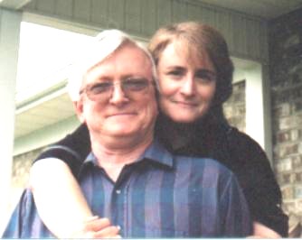 The boss is on the right |
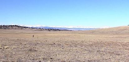
| This is the view looking due north from the house. The snow-covered mountains are the Continental Divide, part of the Colorado Rockies. Karen wanted the backside of the house facing north so Mike would have this wonderful view while he was washing the dishes. We are in a valley at 9,300 feet. Those mountains are about 40 miles directly north of us. Their peaks are over 13,000 feet above sea level. |
|
| Trivia question: Why are these mountains called the Continental Divide? What geographical happening signifies the Continental Divide? |
Living Off The Grid
|
| We have been living off the grid since we moved to Colorado in the fall of 2000. Click here to read a detail of what it is really like to live on solar and wind ten miles from the nearest power lines. It is not the pretty picture presented by renewable energy advocates. |
|
|
| |
|
To get to town, we have to use County Road 53. It's twelve miles of unpaved road. Park County regularly has road graders ditching and leveling the dirt roads. They leave behind a fine crop of sharp rocks which cause a lot of flat tires. A lot of flat tires.
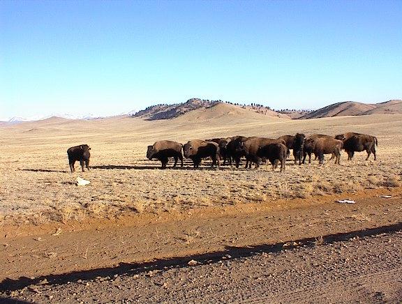
Sometimes the local bison get loose from their grazing areas and have meetings rather near the road or on the road. Unlike the cattle, these guys don't always shy away from a motor vehicle. They are not domesticated. And there is the question of years of inbreeding. They can get downright ornery when they have to get out of your way. The popular name for theses critters is American Buffalo but they are really in the bison family. |
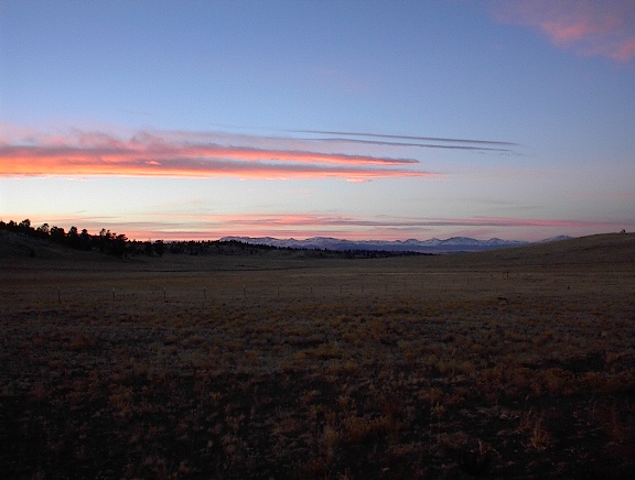
| SUNSETS | |
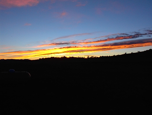
| Every so often, we get really nice sunsets. So nice, that we have to take two pictures of it. The left picture is due west of the house and the right picture is a continuation picture to the north of the house. | |
| 
|
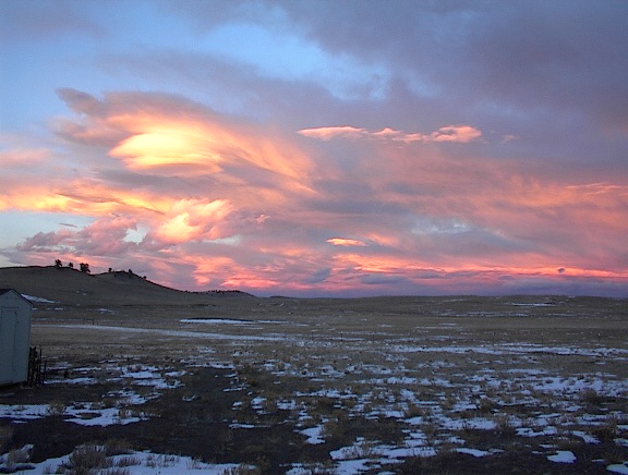
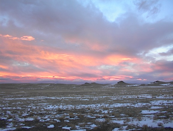
| REVERSE SUNSETS | |
| 
|
| What's really different is a reverse sunset. This colorful sunset isn't in the west but in the east. It happens sometimes in wide valleys when the clouds are just right. On November 5, 2002, we had a spectacular reverse sunset. These two pictures overlap about 25% and show the view from our house looking to the northeast while the sun was setting in the west. And yes, that is snow on the ground. The City of Denver is in that direction some two hours away. | |
| Moon Rise | |
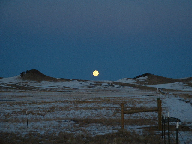
| Clear nights and high altitude makes for some spectacular full moon risings. This view was from due east from our front gate. The City of Colorado Springs is about 45 miles in that direction. March snow is on the ground. |
Monsoon Season
|
The word monsoon is most often equated with South East Asia and other tropical climates. In Colorado, the word is used by locals
to describe the almost daily rains we usually get in late July. We get almost daily thunderstorms here and even heavier daily thunderstorms on the front
range where Denver and Colorado Springs reside. It is not unusual for the front range thunderstorms to drop 4 to 6 inches of rain
along with tornados and large hail. It happens way too often. But, since the thunderstorms are scattered, so are they heavy rains, tornados and hail.
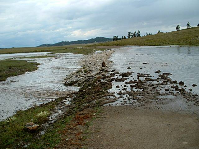
| Here, in the middle of Park County, a heavy rain will run ½ inch. Most thunderstorms are less but the moisture accumulates day after day and many county roads that are dirt, like County Road 53, get slippery as owl snot. Our hail is usually about the size of marbles or less and tends to be softer than the golf-ball sized hard hail on the front range. Park County has only had three tornados, all in the last three years (2012 and 2014) with only one touching down in Lake George in 2014, about 25 miles east of us. |
FLOODING
|
In desert areas, one will see flash flood warning signs for motorists. Desert sand does not hold moisture well. Spring rains have
caused furious and deadly flash flooding. We have our own version of flash flooding around here. At 9,300 feet? Yes, we get flooding. Every
three or four years. Most flooding takes place in the summer when thunderstorms and hail arrive back-to-back. A few years ago we
had a spring-time flood when we got several April snowstorms followed by immediate warming. The ground was soaked.
| Our area is considered "dry" or semi-arid. Again, we are exactly in the middle of Colorado in a valley at 9,300 feet surrounded by many 13,000 and 14,000 (plus) feet high mountains. When we get rain, contrary to what many "environmentalists" claim, the ground around here soaks in the moisture and keeps it. Day after day after day of monsoon season thunderstorms can create very soggy conditions. When waterlogged ground and heavy thunderstorms unite, we get flash flooding. Standing at our house looking around, one would not guess that we are at the low end of a large drainage basin. We found out when we experienced the first flash flood. If our house had been located fifty feet further back our crawl space would have become an under-house swimming pool.
|
|
We typically get about 15 inches of rain a year. Sometimes more, sometimes less. For a stretch we got rain, rain and more rain. The ground
was soaked. On Friday, August 20, 2004, we got another storm followed by a lot of hail. The ground was white from the hail.
Another thunderstorm followed and stalled over the area. What happens then? The new rain melted the hail and then flash flooding.
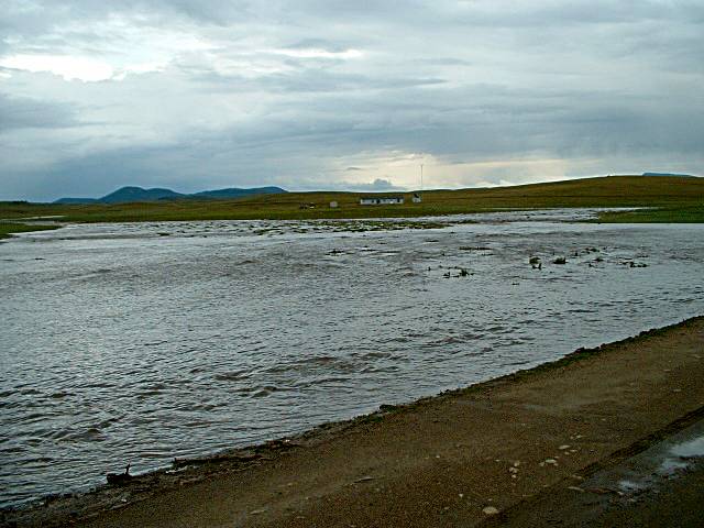
The water rushed down so hard we could hear the rumble of the water. This is a shot of our house from the north side showing some of the water that day.
This is NOT standing water. It looks like a pond but it is a steady and heavy flow, as can be seen in the next picture.
These pictures were taken around 5pm. Our house is the dim white spot just to the right of center, in the dark strip between the water and the horizon. To the far left side of the picture the river of water is flowing down to where we stood on County Road 53, about ½ mile from the house.
When we turned around, facing north away from the house, this was the water flowing over County Road 53 right where County Road 53
meets Chimapavi Trail. The culverts, larger than average, cannot not handle the volume of water. The culvert at this location is large enough for a man
to crawl through. The water on the road was several inches deep. The only reason the road did not fully wash out was because the water had backed
up over a large area and the force of the water was spread out as it flowed over the dirt road, County Road 53.
To the right front you can see that some of the water flowed down the road instead of over it. Our nearest neighbors were not as lucky.
That flow of water in the left of the picture was heading their way.
The side road from County Road 53 to their house washed out and was impassable.
|
SNOW
|
The winters here usually are not as bad as people think, snow-wise. The weather is unpredictable because of the various mountain ranges around us
many with peaks over 13,000 feet and 14,000 feet (the 14K mountains are called Fourteeners out here). Weather fronts tend to move around the
mountains or bounce off them, making weather predictions somewhat of a guessing game. We're in a valley at 9,300 feet and while we do get
snow from the north it is the snowstorms that come up from the southwest that really do the damage. Those southern storms carry moisture
from the Pacific or the Gulf of Mexico and like to make things interesting if there is a cold airflow from the north. The snow tends to blast in from
the east off the front range.
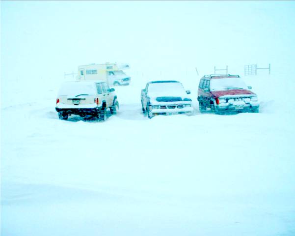
| We started taking pictures. This picture was taken January 5, 2007. The snow in this picture was moving horizontally from left to right That's correct, horizontally. Did we mention the wind? Relentless. We figured we were going to need photographic proof of why we couldn't get out to the post office some 15 miles away along unplowed snow-covered dirt road.
| 
| |
|
The winters of 2006-2007-2008 were doozies. Beginning the weekend before Christmas 2006, "let it snow" became more
than a melody. In a five-week period we got six major snowstorms that dumped on us. The first storm liked Colorado so much it stayed a day
longer than projected. These storms seemed to all hit on Thursday, Friday, and/or Saturday. The first storm being a two day event. The snow
around here tends to be dry which makes it perfect for skiing and drifting. Did we mention the winds? Relentless.
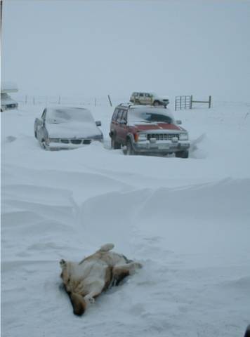
We finally managed to get the Jeep up to the road. Being smarter than we look, which is fortunate, we began parking Jeep #1 on Maskoke Trail, because just driving up to the road was a chore. The wind was constantly changing direction and re-drifting the snow every night. But the snow did not bother our dog, Killer, who loved to roll around in it.
The winter of 2007-2008 was even worse. Park County declared a "snow emergency" and was borrowing snow equipment from
neighboring counties in order to send deputies and rescue personnel to see what rural residents were still alive. Some people had been seen or
heard from for weeks.
The winter of 2013-2014 was bad. The county will not plow to the door of homes far removed from the snow emergency routes.
We sit about ½ mile off of County Road 53, which is a snow emergency route. The county will plow to our front gate. A family five miles
past us on Maskoke Trail was out of luck. They were effectively snowed out of their property for most of the winter. The drifting was so bad their
truck could not make it in through the snow.
|
Francis
|
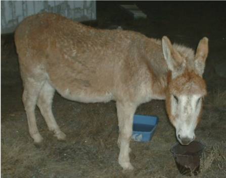
So, you ask, what does it take to liven up our day? A visit from Francis, of course. He dropped by one Monday
morning around 530am and announced, rather loudly at our bedroom window, that he was hungry. So, not knowing the donkey words for, "Sorry
we're all out of Donkey Chow", we fed him. We discovered donkeys like Cheerios. His owner came and got him
later that day. Took us several hours to locate his lost owners.
|
| |
Living at 9300 feet In The South Park
|
The South Park | Park County is physically located smack in the middle of the State of Colorado. Except for the northeastern corner and a small slice of the eastern side, the rest of the county is referred to as South Park. Yes, the same South Park as in the television cartoon. Population of the South Park area is less than 3,000. The Continental Divide makes up the western and northern sides of Park County. The mountains are mostly over 10,000 feet high with many over 13,000 and 14,000 feet.
Altitude
Winter Temperature
Wind
Heating
Water
Power Sources We installed a wind generator a few years back. It is on the top of a 65-feet high aluminum pole we like to call our lightning rod. Lightning not only fuses the generator but burns out the supporting electrical equipment: the controllers and the inverter. After a few strikes we had a lightning arrestor installed. So far, so good.
Shopping In Fairplay, about twenty minutes north of Hartsel, the is a small grocery store, a hardware store, three gas stations, county offices, a small variety of eating establishments, and a variety of shops for the tourists.
Roads
Critters
|
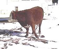
| Lots of cattle and some bison and the occasional horse roaming about. This is open range and animals run loose in a lot of areas. There are a few loose long horn cattle here and there. The bison are supposed to be penned but they do get loose. Roaming loose we find llamas and donkeys, called burros out west, but very few. Ranchers will include one llama or one burro in with a group of cows for protection from large predators. |
| Wild Animals |

| Hundreds of proghorn antelope reside in large herds in the winter and in small groups in the summer. There are a few deer and even fewer elk around here. The deer and elk tend to stay further north of us. According to local lore, one can estimate the winter by how large the herds of antelope are. Larger than normal herds mean a severe winter. Smaller herds mean a mild winter. that is, if one supposed the antelope watch the Weather Channel. What is often not observed is young antelope. They are hidden by the mothers and fed by mom in secret to avoid preditors. |
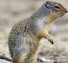
| Ground squirrels, not to be confused with their lower-altitude cousins, the prairie dog, dig holes everywhere. Prairie dogs dig holes but tend to to also pile up the dirt around their holes making a distinctive marker, unlike ground squirrels. Groungd squirrels are burrowing rodents and pests. Tree squirrels are considered to be game and the hunting of tree squirrels is regulated. Ground squirrels are varmits Like prairie digs, they are flea-ridden and disease-ridden pests, and are trapped as such. They are varmits. Their smaller brethren, picket pins, are related and similar to chipmunks, and appear to be cute, but are burrowing rodents as well. And of course, there is the ever present field mouse, small, destructive and breeds like a democrat, |
|
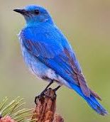
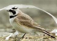
| Mountain blue birds and swifts nest nearby and we have a lot of hummingbirds. The number of summer birds is much higher than we expected. During the winter we have a lot of horned prairie larks who seem to be reliable predictors of approaching storms. They go into a feeding frenzy just before bad weather. We get a brief appearance from a variety of other migratory birds as well. |
|
| We get more than the occasional badger. They tend to dig a lot of large holes, either looking for a ground squirrel snack or just digging a place to sleep for the night. They dig holes very quickly. And deep. We have not seen any bears around here yet but or neighbors have. And one did see a mountain lion nearby. Coyotes are common out here. Unfortunately, village idiots occasionally come out here to shoot coyotes for fun. 95% of a coyote's diet consists of rodents and insects. They help keep nature in balance. |
|
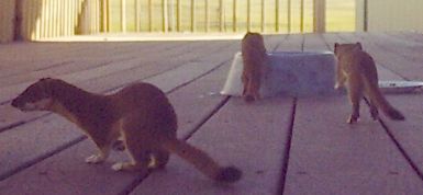
One year we had an over-wintering mountain weasel that had a spring litter of five young ones. They were fun to watch.
They eat ground squirrels which we considered a plus. Long and thin, they go into the ground squirrel burrows and catch them napping.
The five babies ran around and rolled around enjpying their environment.
This picture was taken on the deck where we had placed a water bowl for them. Since there is no body of water nearby they left for other areas. They make their homes near water. |
| ||||||||||||||||||||||